
 (850) 213-0040
Introduction
Most people start planning a first trip to 30A the same way: a search that opens fifteen browser tabs, three community names, two airport codes that do not match anything on the map, and no clear answer about where to stay in 30A. Visiting 30A is one of those destinations where the gap between the research experience and what arrival actually looks like is unusually large. The corridor is far simpler than the research makes it seem.
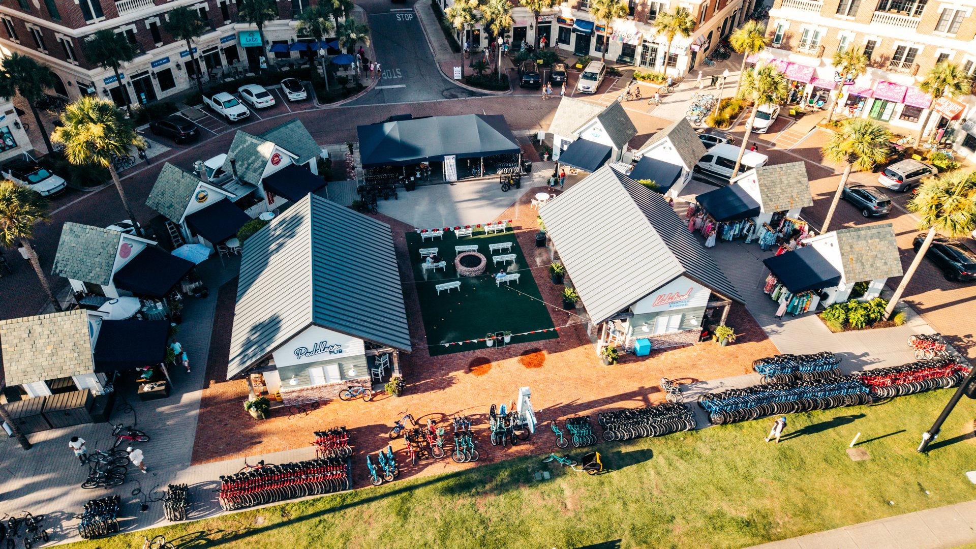
This 30A travel guide cuts through the two decisions every first-timer faces before anything else: which end of the corridor to stay on, and whether to keep the car after the airport drive. For the airport leg of how to get to 30A Florida, ECP serves the eastern end and VPS the western end. For the logistics on arrival day, bike rentals at the Seacrest Beach trailhead handle the most important part of Day 1.
What 30A Actually Feels Like (and Why It’s Nothing Like Destin or PCB)
Most visitors approach 30A expecting a beach town. What they find is more like 15 small beach towns that happen to share a trail.
The character difference is structural, not cosmetic. Scenic Highway 30A runs through South Walton County on the Florida Panhandle under building codes that cap height and require architectural review for new construction. No high-rise condos face the beach. No chain restaurants line the main road.
Rosemary Beach is regulated to a Georgian architectural vocabulary. Alys Beach is all white Moroccan minimalism. Seaside was the first large-scale New Urbanist development in the United States and served as the filming location for The Truman Show.
Each community looks deliberately different from the next. The result, for a first-time visitor standing at the Seacrest Beach trailhead on a Tuesday morning, is the feeling of a place built for people who actually live here rather than for visitors passing through on a long weekend. That is not accidental. It comes from decades of restrictive planning covenants and community-level design standards that no amount of marketing can replicate.
The Gulf of Mexico frames the corridor from the south. The water runs unusually clear by Florida standards: quartz-white sand creates the turquoise and emerald tones photographers associate with the Caribbean. Coastal dune lakes, a geographic rarity found in fewer than ten locations on Earth, appear between communities along the corridor. They are not swimming spots, but they are among the rarest landforms most visitors will ever walk beside.
For a first-timer, the practical implication of all of this is simple: do not expect a generic beach resort. Expect something that takes a full day to calibrate to.
East End or West End: Where to Stay on 30A Based on What You Want
The biggest planning decision for where to stay on 30A is not which vacation rental photographs well. It is which end of the corridor actually fits the trip.
Most guides answer this question by listing communities in order. That does not help a first-timer decide. The honest framework: the eastern end and the western end feel like two related but distinct destinations, and the week plays out differently depending on which one is home base.
The eastern end: Rosemary Beach, Alys Beach, Seacrest Beach, Inlet Beach
The eastern corridor runs from Inlet Beach west through Seacrest Beach. This section holds the highest concentration of architectural set-piece communities on the corridor: Rosemary Beach with its cobblestone courtyard and Georgian-style buildings, and Alys Beach with its stark white Moroccan-influenced design. Both are among the most-photographed stretches on all of 30A.
Seacrest Beach sits between Alys Beach and Inlet Beach and holds the eastern Timpoochee Trail trailhead. Access to the full 19-mile paved corridor begins here. First-timers based on the eastern end are on the trail within minutes of leaving the rental property.
Rental prices on the eastern end reflect the architectural prestige of Rosemary and Alys Beach. They run at the upper tier of the 30A range, particularly for properties with Gulf views or direct beach access.
The western end: Grayton Beach, WaterColor, Seaside, Blue Mountain Beach, Santa
Rosa Beach
The western end carries a different character. Grayton Beach, consistently rated one of Florida’s top-ranked beaches, holds an Old Florida aesthetic: weathered wood, scrub oak canopy, and lower architectural density compared to the eastern end. Grayton Beach State Park provides access to coastal dune lake kayaking, hiking trails, and some of the least-crowded beach on the corridor.
WaterColor and WaterSound sit adjacent to Seaside on the western approach. Seaside occupies a position near the geographic midpoint of the corridor, which puts both ends of the Timpoochee Trail within comfortable day-trip biking distance.
The decision
For first-timers who want architectural character and quick trail access from the eastern trailhead: eastern end. For visitors who want state park proximity, a more relaxed Florida Panhandle pace, and slightly lower average rental prices: western end. Seaside near the midpoint works for either group, with Rosemary Beach to the east and Grayton Beach to the west both reachable on the trail in under an hour.
Why Most Visitors Park the Car and Don’t Touch It Again
Every guide about 30A mentions that bikes are available. None makes the other half of the argument: that a car on 30A during peak season is an active source of friction, not a neutral option.
Scenic Highway 30A and the parallel US-98 become genuinely congested on peak summer Saturdays. Two-lane sections between communities can turn a half-mile inter-village move into a 20-minute crawl. Beach parking at the most popular access points fills before 9am on busy summer days. Several lots require exact cash. Some of the eastern communities restrict golf carts within their boundaries, leaving bikes and foot traffic as the only car-free alternatives inside those areas.
The Timpoochee Trail covers the same inter-community ground on flat, paved, car-free surface at the same effective pace as a car under summer conditions, with no parking fees, no traffic signals, and no queue at the beach access.
Research from the Adventure Cycling Association on trail-based tourism in the United States consistently identifies dedicated car-free corridors as a primary driver of repeat visitation. Visitors who shift their primary transportation to trail access during the trip report higher satisfaction and return at higher rates than those who remain car-dependent at the same destinations. The 30A pattern reflects this: the visitors who come back year after year are, with striking consistency, the ones who parked the car on Day 1.
For the airport-to-house leg, two airports serve the corridor. Northwest Florida Beaches International Airport (ECP) near Panama City Beach is the right choice for the eastern end, roughly 35 minutes from Rosemary Beach and Seacrest Beach. Destin-Fort Walton Beach Airport (VPS) covers the western end, roughly 35 minutes from Santa Rosa Beach and WaterColor. After the arrival drive, the car’s job is done until departure morning.
Your First Day on 30A: A 30A Itinerary That Always Works
The best 30A itinerary for a first visit is not complicated. It is consistent.
7:30am: Pick up bikes at Peddlers Pavilion at the Seacrest Beach trailhead. Get fitted. Confirm bike types match the group: beach cruisers for adults, Burley trailer attachments for children under 5, tag-along bikes for ages 4 through 8. Electric bikes (e-bikes) are available for visitors who want pedal assist on longer rides.
8:00am: Head east on the Timpoochee Trail toward Alys Beach. The first 0.8 miles from Seacrest Beach pass through coastal scrub oak before opening to the Alys Beach interior street. Walk the white architecture for 10 minutes. It is the most visually distinct stretch on the eastern corridor and one of the few places in Florida that looks like nothing else in Florida.
8:30am: Continue east 0.8 miles to Rosemary Beach. Lock bikes at the town square rack. The cobblestone courtyard and Georgian-style buildings are the most-photographed section of the eastern corridor. Coffee at one of the courtyard cafes before the trail gets busier.
9:30am: Ride back west past Seacrest Beach to the Gulf access. Morning conditions are typically the calmest of the day. Water clarity on a calm morning is noticeably different from what most Gulf Coast beaches offer.
10:00am onward: Ride at will. Visiting 30A from this point forward is a matter of direction and pace. Families extend west toward WaterColor and its beach club access. Couples push toward Seaside and the coastal dune lake at Deer Lake State Park. Groups ride the full Timpoochee Trail corridor and see what there is to find. Any direction from Seacrest Beach reaches a named community within 15 minutes at an easy pace.
Evening: Return bikes. Dinner in Rosemary Beach or WaterColor depending on where the afternoon lands. Both are reachable on the trail if bikes are still in hand.
This plan holds for a family, a couple, a group of friends, or a solo traveler. The Timpoochee Trail is the same corridor for all of them. What changes is pace and which communities anchor the day.
Practical Tips First-Timers Always Wish They Had Known
No matter how much research goes into planning for a first time visiting 30A, certain things only become clear once someone who has been at the Seacrest Beach trailhead every day for fifteen years explains them.
Check beach flags before you swim. Every 30A beach access point flies color-coded flags indicating Gulf conditions. Green means safe. Yellow means caution, currents are present. Red means no swimming. Double red means the water is closed by county order. Flag conditions change daily and matter more on the Gulf Coast than on protected bay beaches.
One grocery store. The only full-service grocery store on the corridor is a Publix between Seaside and Seagrove Beach. Stock up on arrival day. Some communities have specialty shops, but the Publix run is unavoidable for longer stays.
Beach parking fills early. The most popular access points fill before 9am on peak summer days. Many smaller lots are cash-only. A bike on the Timpoochee Trail eliminates this problem entirely.
Book bikes before you book excursions. For June through August visits, bike rentals at the eastern trailhead fill the way restaurant reservations do. Book the morning after the rental house is confirmed. Arriving in July expecting a walk-in rental on peak dates is a gamble.
Coastal dune lakes are not swimming spots. The dune lakes that drain into the Gulf at controlled outflow points are among the most photographically striking features on 30A and some of the rarest landforms on the Emerald Coast. They are suited for kayaking and paddleboarding, not Gulf-style open swimming.
For the full range of trail-accessible experiences on the 30A corridor, conditions and availability vary by season.